A powerful nor'easter traversed the Mid-Atlantic and Northeast on Tuesday, mostly bringing rain to the I-95 corridor from Washington, D.C., to New York City. Farther inland, however, from Scranton to Albany and up into Maine, colder air collided with moisture, blanketing these areas with accumulating snow.
New Jersey Gov. Phil Murphy issued a state of emergency in the northern part of the state, including Hunterdon, Morris, Passaic, Sussex, and Warren counties. He urged drivers in the area to "exercise caution, remain alert, and follow all safety protocols."
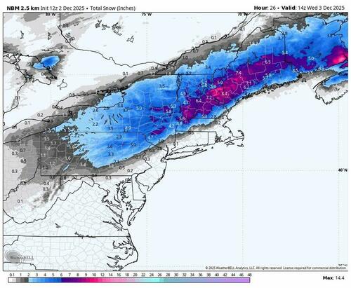
Today's snowfall is confined to a narrow but intense band stretching from the Ohio Valley through central Pennsylvania and the Catskills into interior New England. Meanwhile, areas along the I-95 corridor will see mostly rain.

CNN meteorologist Derek Van Dam said the storm could intensify into a bomb cyclone if its pressure continues to drop as it approaches the coast, which would bring even stronger winds along with torrential rain and snow.
Millions are under winter weather alerts from Ohio through Maine.

Looking ahead, AccuWeather Chief On-Air Meteorologist Bernie Rayno warned of another wintry system arriving late Friday into Saturday that could bring snow to parts of the Northeast.
"Should the cold air push too forcibly into the Northeast late in the week, the storm will escape out to sea with mostly rain for the Southeast and perhaps a narrow zone of snow, ice, and rain or snow on its northern edge," Rayno said.
He noted, "However, should the cold air sit back just a bit in the Northeast and let the storm strengthen as it nears the Atlantic coast, it could turn into a heavy snow accumulation from the southern Appalachians and Piedmont all the way to the interior mid-Atlantic and much of New England."

Earlier, NatGas futures rose to a three-year high on new models suggesting colder weather across the eastern two-thirds of the country for Dec. 6 to 10, with additional cooling expected from Dec. 11 to 15. Read the report.

Loading recommendations...