An experimental satellite has mapped the scale of GPS jamming across Europe and the Middle East from space for the first time.
The data surprised the team behind the project and indicated that satellites orbiting far from Earth aren't the only ones that experience degradation of their positioning, navigation and timing (PNT) signals, which could affect their performance and the safety of their operations.
The new measurements were made by Pulsar-0, the first satellite of the novel Pulsar navigation constellation developed by California-based Xona Space Systems. The experimental satellite orbits 310 miles (500 kilometers) above Earth, testing Xona's technology before the company begins deploying its navigation constellation of 300 spacecraft in low Earth orbit (LEO) later this year.
The purpose of the Pulsar constellation is to provide a more resilient PNT service compared to the United State's GPS network and other global navigation satellite systems (GNSS), such as Europe's Galileo or China's Beidou. The PNT signals distributed by GNSS satellites underpin many systems that our civilization relies on in everyday life, including the operation of power grids, finance operations and oil drilling.
But because GNSS satellites orbit quite far from Earth — at altitudes abve 12,000 miles (19,000 km) — the signal that ground-based receivers detect is weak and can be easily jammed.
GNSS jamming (the overpowering of GNSS signals with noise) and spoofing (which involves overriding the original signals with false ones carrying incorrect coordinates), have become almost a global emergency over the past five years.
For example, Russian jammers have been disrupting GNSS signals along Russia's western borders, officially to protect the country from Ukrainian drone attacks. Every month, this interference affects tens of thousands of flights that cruise over the region. The warring parties in the Middle East, too, use jamming and spoofing to deflect drone attacks and hide the positions of illegal ships at sea.
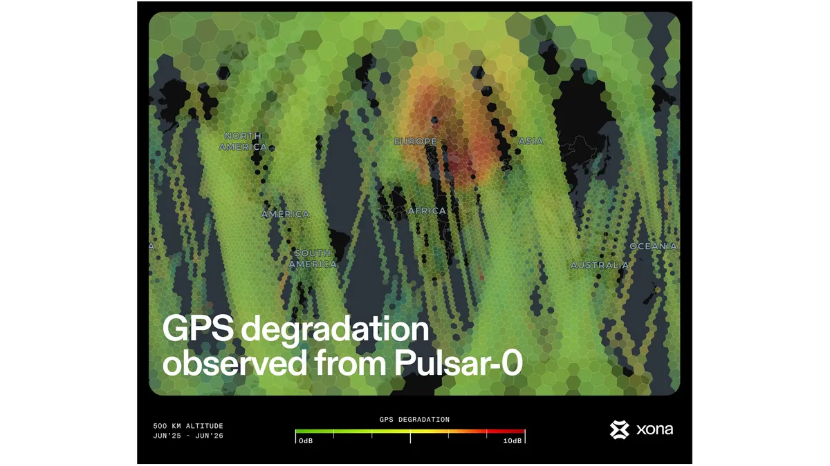
Xona's satellites will use a similar signal, but one that's 100 times stronger, to offer greater resiliency against such deliberate interference. But the Pulsar-0 spacecraft also carries a GPS receiver to make sure the two systems will be able to work together. When the Xona team first turned on that receiver a few months after Pulsar-0's launch last year, they were shocked by the scale of signal degradation the receiver was reporting above Europe and parts of the Middle East.
"When we fly over North America, for example, we see a beautiful signal all the time," Kaz Gunning, Xona's co-founder, told Space.com. "But as soon as we started doing any operations above Europe, we noticed that there was really something going on there. We thought we were going to see some jamming, but it's quite a bit more than we expected."
In the hardest-hit areas, the strength of the GPS signals at the satellite's altitude dropped from the regular 40 decibels to as little as 10 decibels.
Gunning says that, due to the altitude of the Pulsar-0 satellite, the map may not truthfully reflect where jamming is worst for users on the ground. The data, however, revealed that satellites in heavily used LEO suffer from some degree of GPS signal disruption all the way from France in the west to the borders of Pakistan in the east.
The measurements mean that satellites in LEO are not out of the reach of ground-based jammers, and that the PNT signals those satellites need to time-sync their operations and determine their position in space can't always be relied upon.
"You lose the GPS capability as soon as you pass over these regions," said Gunning. "That may be a problem for imaging satellites that are trying to position themselves to take images of a certain region. You can't do altitude determination, you can't do the positioning without the GPS signal. You can't even accurately point at your telecommand antenna on the ground. That's generally going to disrupt satellite operations."
Satellite constellations such as SpaceX Starlink also rely on GPS to avoid collisions with other spacecraft.

It's not just deliberate jamming and spoofing that can wreak havoc with the precious PNT signal. Severe solar storms, too, can cause serious disruptions. The Gannon superstorm in May 2024, for example, distorted the GNSS signal so much that precision farming machinery in parts of the U.S. couldn't operate for days. Technologists are therefore racing to find backup solutions to transmit the PNT signal to everyone who needs it whenever GNSS is down.
Xona hopes that the Pulsar constellation, once up and running, will make the lives of those dependent on GNSS much easier.
Gunning says that, with the superior strength of the PNT signal transmitted by the company's planned LEO constellation, existing jammers would only be able to affect about 5% of the area they can currently disrupt.
"The effect of the jamming is going to be reduced to a smaller radius," Gunning said. "The degradation area will go down, and the full lock-out radius will also go down."
Xona plans to launch a batch of six satellites in October and begin ramping up production shortly thereafter. The company raised $170 million in a "Series C" funding round this March and hopes to begin delivering basic service in early 2027.
"We expect early customers in timekeeping to begin utilizing Pulsar at the end of this year with intermittent coverage," Max Eunice, Xona's head of communications, told Space.com. "Pulsar's capability will increase with every subsequent launch, unlocking new advantages for new customer segments as our constellation fills out."