US natural gas futures erupted Monday morning as some of the coldest Arctic air of the Northern Hemisphere winter season poured into the eastern half of the Lower 48. Snow threats across the region are increasing through the end of the month.
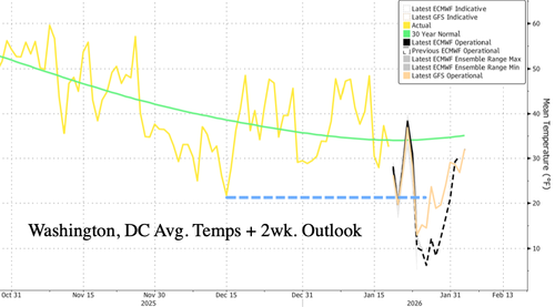
Average temperatures across Washington, DC, are plunging and could average around 10°F by the weekend. This cold blast is far more extreme than the one in the first half of December. Notably, this period typically coincides with the most intense part of winter.

"DANGEROUS COLD is likely on Saturday across much of the United States, with wind chills forecasted to fall below zero for over 100 million people," weather observer Max Velocity wrote on X. "Additionally, wind chills could be as low as 60 DEGREES below zero in the far Northern Plains at this same time. This dangerous cold will likely set up a rare Southern USA Winter Storm on Friday and Saturday."
Private weather forecaster BAM Weather warns of increasing risks of winter activity across the eastern half of the US this week:
A storm will develep Friday night into Saturday across the deep south and track northeast with a tap to the Gulf of America allowing plentiful moisture to produce a large area of a high impact winter storm. Strong high pressure will come south from Canada and bring Arctic air with it allowing there to be plenty of cold air available to produce snow and ice across several thousands of miles in the central and eastern US.
Winter Storm Scenario #1

Winter Storm Scenario #2

The cold blast has sent heating demand through the roof.

NatGas futures in the US are up 18% as of early Monday, the largest intra-day jump since October 2024.

NatGas prices surging again.

Cold air is in place. The weather pattern is set.
All eyes are on the next possible major snowstorm targeting the Southern Plains, Mid-South, Appalachians, and Mid-Atlantic by next week.
Loading recommendations...